
Earthquake Table Top Exercise
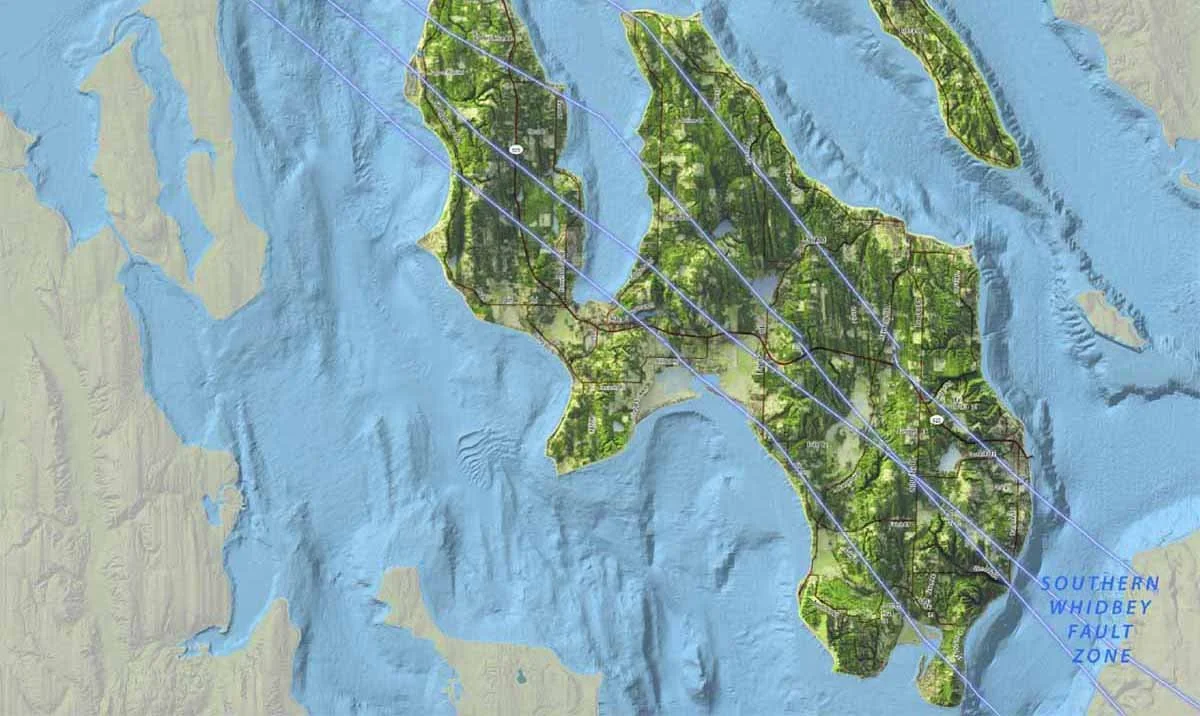
Our Southern Whidbey Island Fault is several miles wide and consists of a slew of cracks. It has been traced to Vancouver Island to the northwest and Fall City to the southeast. More recently lidar images suggest it connects to Hanford and Rattlesnake mountain in the south east corner of Washington
Create a test scenario and practice your earthquake preparedness
I encourage you to make this as relevant to your particular neighborhood as possible. If you want to change the scenario to a different day of the week, or season or time of day please do so. If you have lots of kids in your neighborhood, you might want to include some questions about coordinating with the schools. If you have lots of farm animals, you might want to add something about caring for them. If you have lots of folks who work off island, perhaps you include details about their work environment. Bottom line – make this yours.
What hazards are most prevalent where you live? flooding from tsunamis or king tide and El Nino conditions; liquefaction; landslides; more-than-normal tree damage; diverse age of homes and the building codes in practice at the time those homes were built....
Consider printing and bringing appropriate hazard maps to your meeting. The Island County Local Hazards section has a good assortment. You can zoom in and print just the parts you need.
Set this up to be fun, to elicit curiosity. Obviously you don’t want to scare people. You want to stretch their imaginations and enable them to see themselves successfully navigating a wide range of disasters. We won’t know how we will respond before the event, by definition. Nor can we anticipate the details of an event that hasn’t happened. But the more we practice scenarios together, the more flexible and responsive we will be when a future event occurs.
Add/delete/change the questions to fit your neighborhood. Make this belong to you. These are suggestions only. Customize as much as you want. Add details that you can imagine. If folks are comfortable doing so you might even encourage them to close their eyes. Can someone add the sounds of an earthquake? What are they smelling? What might it feel like to have the very earth under our feet ripple? If someone in your neighborhood has actually experienced an earthquake, perhaps they can add some color commentary and describe what they felt and thought while it occurred.
Details to describe the practice earthquake
Wednesday, April 14th, 10:20 am - the day is clear and unseasonably warm
7.4M earthquake occurs along the SWIF, centered approximately in Langley (Aftershocks will continue for 2 days because the SWIF is shallow and hence more prone to aftershocks)
South of Coupeville we experience severe shaking
North of Oak Harbor has very strong shaking
Like us, Camano receives severe shaking
Reports of significant damage in 18 counties
Starlink is slow (probably from so much use?)
Power is out throughout all of Puget Sound
Cell service is out; several towers are literally down
Liquefaction damaged is significant
Landslides occurred in all the historic places
3-foot vertical displacement along SR-525 has limited access to Langley and Clinton
We learn later in the day that:
Water systems and waste water treatment facilities in Coupeville and Langley are compromised. A county-wide “boil water” notice is issued
Most HOAs are without water at least in the short term until company reps can get to the island for repairs
The Mukilteo, Keystone and Pt Townsend ferry docks are damaged and out of commission
Deception Pass bridge awaits inspection
Reflection questions
Where would your housemates likely be at the time of the quake (10:20 on a Wednesday morning)?
How will you affirm all are okay?
How do you anticipate your animals would react?
How might your house fare? Are you in a liquefaction zone? Tsunami inundation danger?
Where would your neighbors likely be? Home? Work? School? Mainland? Up island?
What damage would you anticipate in your neighborhood? Any fires?
Who would likely need extra help?
How much could you depend upon each other?
What help from “outside” would you need? What could you not do for yourselves with the skills and resources you have? And might they be available in the adjacent neighborhoods?
About fault zones throughout the Salish Sea
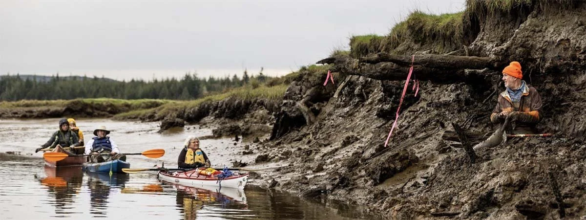
How we got here.
Isn’t it interesting how recently we have “figured out” earthquakes? Only 40 or so years. We of course have all the stories from generations past but scientific evidence was hard to come by. It’s not like seeing a lava flow and saying, oh- there was some volcanic activity here in the past. One of the most devoted and tenacious researchers was Brian Atwater. He’s currently a research professor at the UofW. He’s a “mud guy” and his curiosity about discontinuous layers of mud established evidence of past earthquakes. He realized the ghost forest at Copalis Beach was evidence of the January 27, 1700 Cascadia Fault mega earthquake. Like many researchers he was initially ridiculed but eventually became a godfather of fault investigations. Look how recently we have become aware of our fault zones throughout the Salish Sea.
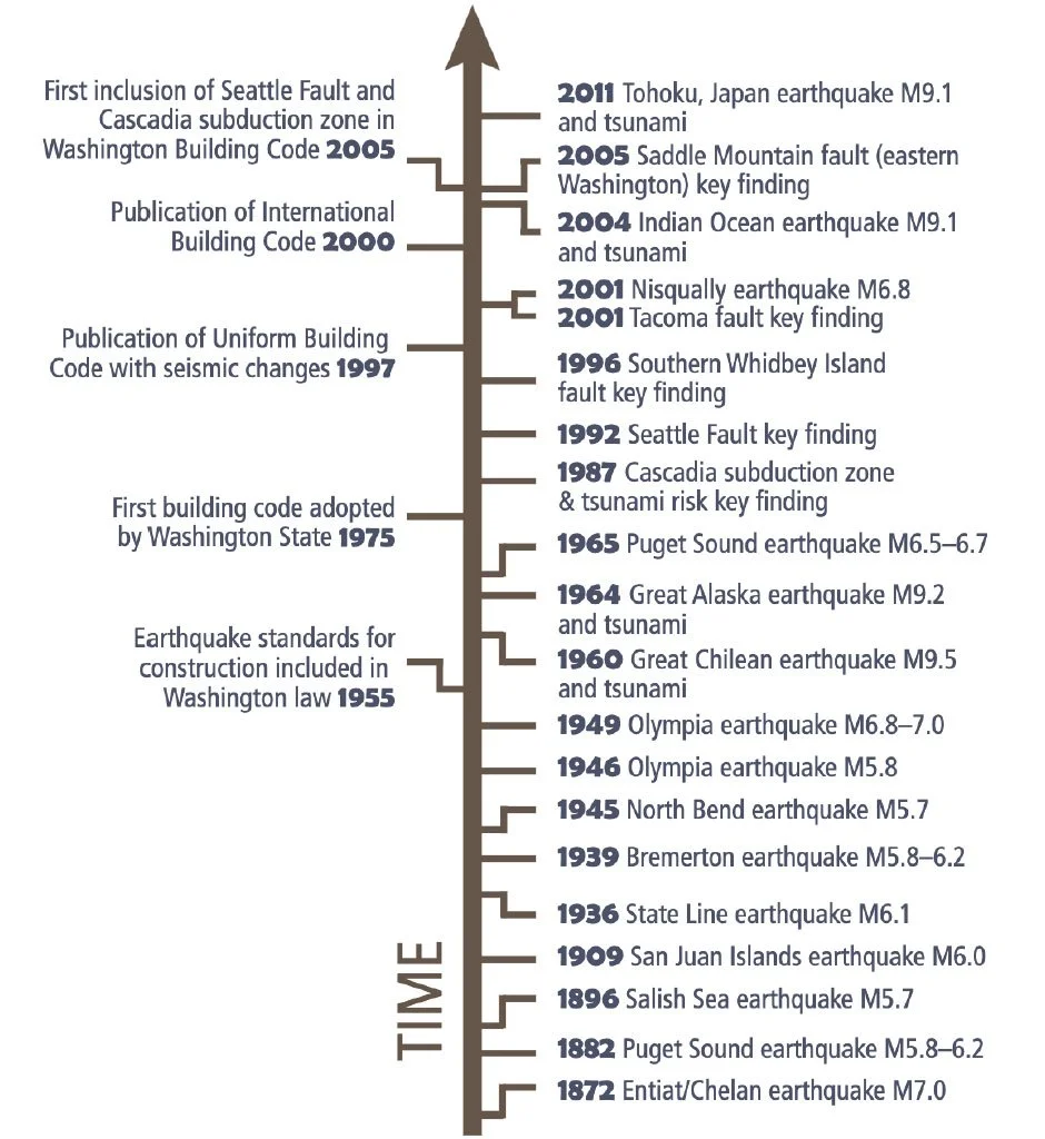
Building codes are relatively new and only just recently influenced by the dangers of earthquakes. We captured this image from a DNR handout on earthquake preparedness.
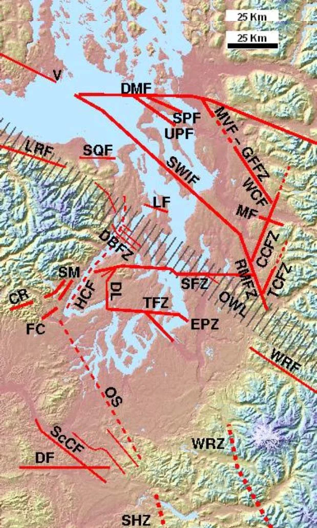
This map of Puget Sound known faults in our region would make a fun jigsaw puzzle. We look rather like the cracked mud after a long drought.
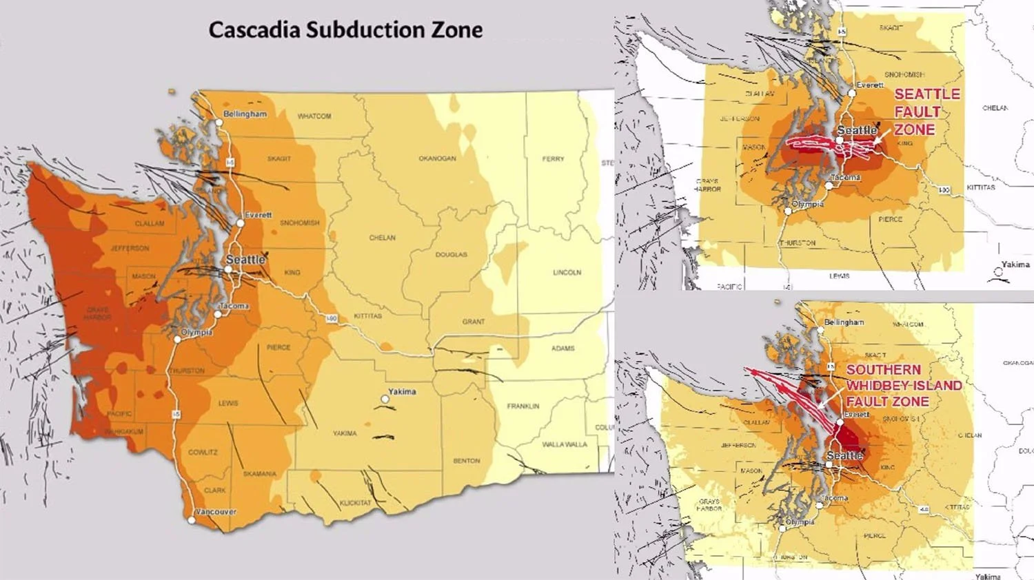
This was a sobering discovery for me. We have been talking about the Cascadia Fault doing significant damage up and down the coast. The Southern Whidbey Island Fault is currently considered to be equally dangerous. Go figure. These images show the relative shaking from the 3 biggest faults in Washington – Cascadia, Seattle and our Southern Whidbey Island Fault. Good news it hasn’t rumbled for 3000 years
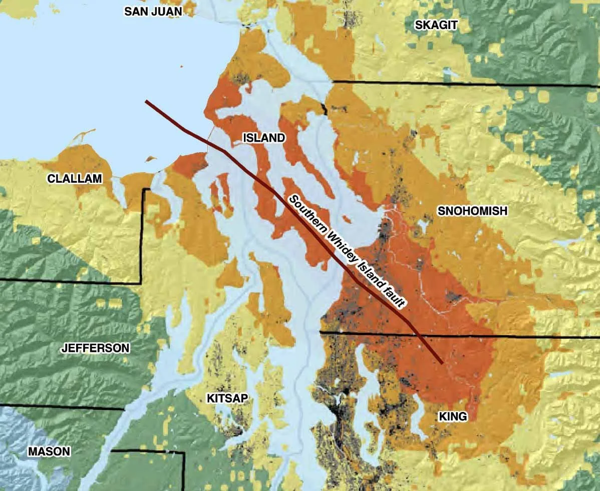
I found this map on the USGS web site, in a paper speculating the damage of a 7.4 earthquake in the Southern Whidbey island Fault. It doesn’t go down the whole coast like the Cascadia fault which is good news. But look how extensively it reaches. In one report I read 18 counties would suffer, all the way to Yakima over the mountains.
South Whidbey Record story about the Whidbey fault
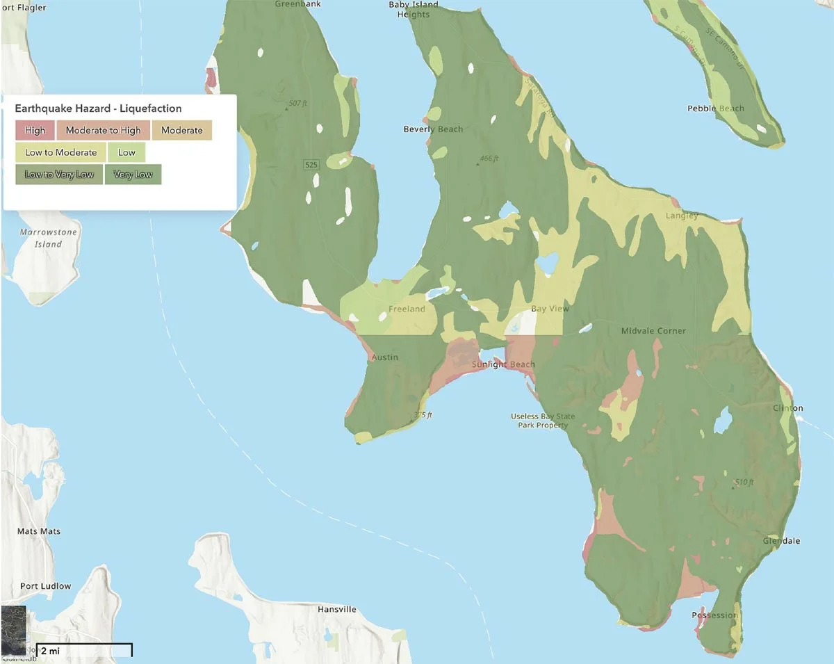
Here is the liquefaction map of the south end of our island. I expected spots all along the coastline, but was initially surprised by how much of the Maxwelton valley and other inland spots all down the Cultus Bay corridor are vulnerable. Is your neighborhood vulnerable. This map is accessible through the county web site under Where Are My Hazards. You can also find inundation and land slide vulnerability maps.